
Hectic weather

"This is your captain speaking, owing to a sudden stratospheric warming over the Antarctic and a breakdown in the Antarctic polar vortex, there will be a bumpy approach into Hobart this morning."
This is not something you will hear from an aircraft captain, not least because it is far too much information and also we'd also probably prefer the flight crew to be focusing on the detail of landing the plane rather than climate science. A climate scientist or a meteorologist are even less likely to suggest a relationship between climate and an event (like a bumpy flight into Hobart or, for that matter, having to return to your point of departure). This is because of something called 'attribution' and it is an entire field of highly specialised study. Attribution science is about understanding the role of climate versus natural weather patterns.
In July this year, ABC Meteorologist Tom Saunders noted that the temperature more than 20 kilometres above the east Antarctic coastline suddenly warmed by about 50 degrees Celsius in a week in early July — an event called a sudden stratospheric warming. This can impact Australia's weather through a weakening polar vortex, which can allow westerly winds to escape the poles and expand towards the equator, a pattern called a negative southern annular mode. A northward migration of westerly winds and cold fronts from the Southern Ocean has historically brought windy, cold and showery weather to Australia's southern coastline from south-west WA to southern SA, Victoria and Tasmania. The article is available on the ABC website.
Windy, cold and showery weather was predicted and this was what was experienced in Tasmania and Victoria. Electricity was cut for some communities for weeks, and there were some postponements of Spirit of Tasmania Bass Strait ferry crossings. Par Avion Flight School, where I train as a pilot, had only limited operations for much of August and September.
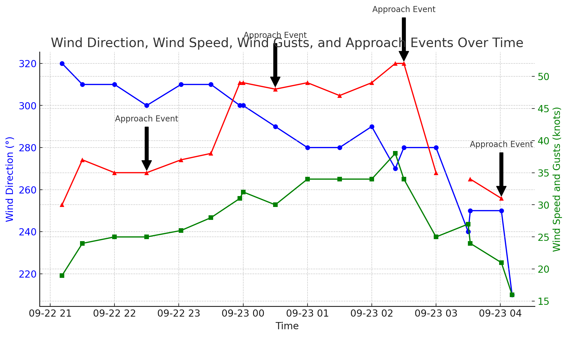
Monday 23 September was the extreme example of the weather pattern. Looking at boats moored can tell you a lot about weather conditions (photo above taken on the morning of 23 September): some pointing to the southwest, some to the northwest or west and the water boiling with whitecaps. Wind data at Hobart Airport on the day were sourced from automated weather observations with data intervals of about 30 minutes. It captures some of the extremes of wind speed experienced but it doesn't really show the variation in both wind speed and wind direction dynamically over very short periods of time as would be experienced by an aircraft on final into Hobart. A video of a wind sock would be a better source of the conditions being experienced by pilots but even then it doesn't tell us about changes in wind speed and direction on descent.
The other notable point about the data is that it doesn't suggest that crosswind was the major issue. By the time that wind direction had shifted more to the south, the wind speed was starting to decrease. The Jetstar Flight JST 719 from Sydney to Hobart returned to Sydney when the crosswind component was about 10Knots and the Virgin flight VA1316 from Melbourne to Hobart returned to Melbourne with crosswinds at about 20knots. Crosswind increased after that but didn't exceed the stated maximum demonstrated crosswind of 38knots for an A320. Perhaps, wind shear was a greater issue for pilots on the day.
Wind shear is defined as a wind direction and/or speed change over a vertical or horizontal distance. It is significant when it causes changes to an aircraft's headwind or tailwind such that the aircraft is abruptly displaced from its intended flight path and substantial control action is required to correct it. An article on wind shear was recently referenced in the Pilot Safety Hub and is available from the Airbus website
Larger aircraft are more susceptible to wind shear because of their greater inertia. When wind shear occurs (a sudden change in wind speed or direction), a large aircraft cannot adjust its speed or direction as quickly as a smaller one. This delay in response makes it more vulnerable to the effects of wind shear. The Airbus article refers to frontal systems and mountain waves as being some of the weather associated with wind shear. Given only moderate cross wind and with the passage of a cold front indicated on the synoptic chart, it seems more likely that frontal wind shear (vertical and/or horizontal) was the most likely cause of the flight diversions and missed approaches on 23 September.
Wind data from Hobart automated weather observations (crosswind and headwind calculated), Monday 23 September 2024
| Time (UTC) | direction | wind gusts | crosswind | headwind | Event |
|---|---|---|---|---|---|
| 2024-09-22 21:11:00 | 320 | 30 | -3 | 30 | |
| 2024-09-22 21:30:00 | 310 | 37 | 3 | 37 | |
| 2024-09-22 22:00:00 | 310 | 35 | 3 | 35 | |
| 2024-09-22 22:30:00 | 300 | 35 | 9 | 34 | JST 719 |
| 2024-09-22 23:02:00 | 310 | 37 | 3 | 37 | |
| 2024-09-22 23:30:00 | 310 | 38 | 3 | 38 | |
| 2024-09-22 23:57:00 | 300 | 49 | 13 | 47 | |
| 2024-09-23 00:00:00 | 300 | 49 | 13 | 47 | |
| 2024-09-23 00:30:00 | 290 | 48 | 20 | 44 | VA 1316 |
| 2024-09-23 01:00:00 | 280 | 49 | 28 | 40 | |
| 2024-09-23 01:30:00 | 280 | 47 | 27 | 39 | |
| 2024-09-23 02:00:00 | 290 | 49 | 21 | 44 | |
| 2024-09-23 02:22:00 | 270 | 52 | 37 | 37 | |
| 2024-09-23 02:30:00 | 280 | 52 | 30 | 43 |
VA 702, Link SF34 |
| 2024-09-23 03:00:00 | 280 | 35 | 20 | 29 | |
| 2024-09-23 03:30:00 | 240 | 27 | 26 | 7 | QFA 1925 |
| 2024-09-23 03:32:00 | 250 | 34 | 31 | 14 | |
| 2024-09-23 04:01:00 | 250 | 31 | 28 | 13 | B737 |
| 2024-09-23 04:11:00 | 210 | 16 | 15 | -4 |
Note: the landing events were placed approximately against a corresponding automated weather observation but conditions could have differed significantly from the observation.
The graph below shows wind speed, wind gusts and wind direction together with particular landing events. It should be said that there were a number of successful landings into Hobart on the day, so landing success depended on the 'luck of the draw' - on the actual conditions experienced by aircraft during their final approaches. The first event was JST 719, which returned to Sydney, then VA1316 returned to Melbourne . In the third event shown on the graph below, there were two flights close together: VA 702 from Brisbane diverted to Melbourne and the Link Airways Flight from Canberra to Hobart had to divert to Launceston (this was at about the extreme of crosswinds). Finally, QFA 1925 from Brisbane entered a holding pattern, as conditions were starting to ease and they landed a while later and a subsequent Melbourne to Hobart flight had a missed approach and went around before landing successfully.
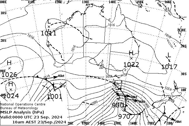
So what does all this mean? This article has gone from very big picture climate issues to a very wild and disruptive weather day on the 23 September. Some conclusions are:
- Sudden stratospheric warming over the Antarctic and a breakdown in the Antarctic polar vortex are still quite unusual events (they are more common over the Arctic), but when they occur we should be prepared for a disruptive period of weather
- Public acknowledgement of this forecasting and climate research is important as the aviation sector is vulnerable to change, such as through direct impacts on aerodromes and airports through extreme weather events and through impacts on aircraft operations.
- An archive of data is available from the Climate Data Services at the BOM, which can be used to better understand weather events against historic patterns.
Just about to finish writing this item and looked up the weather at Hobart Airport: Surface wind: 310T at 23 knots gusting to 33 knots and severe turbulence. Still beyond my personal minima but hopefully, a final burst of hectic weather before calmer days ahead.